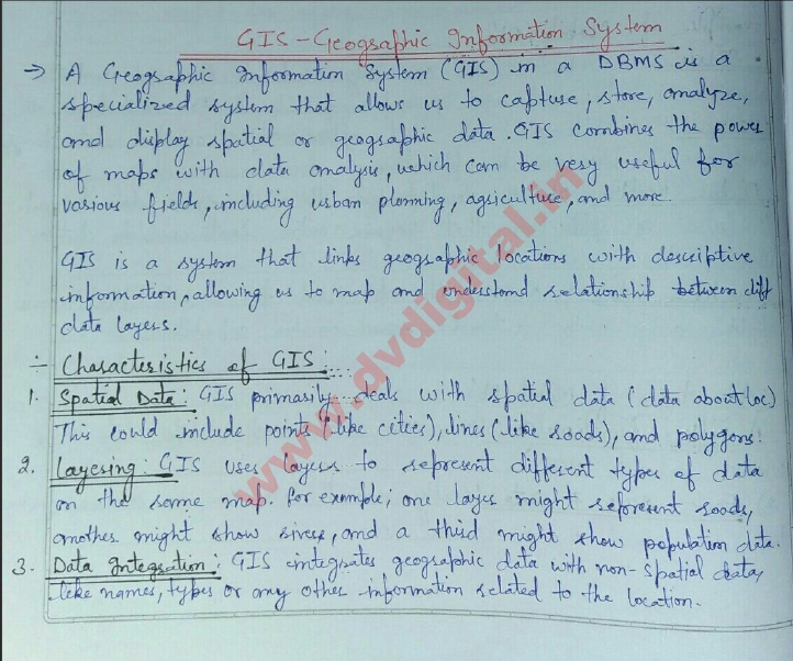
Geographic Information Systems in DBMS Handwritten notes-
🌍 What is a Geographic Information System (GIS)?
A **Geographic Information System (GIS)** is a computer-based tool that helps capture, store, analyze, manage, and visualize geographic data—information linked to specific locations on Earth’s surface. GIS combines spatial data (locations, shapes) with attribute data (details about those locations) to create a rich visual layer of information. It’s widely used across various fields such as urban planning, environmental monitoring, resource management, and transportation.

🗂️ Role of GIS in Database Management Systems (DBMS)
A GIS uses a **Database Management System (DBMS)** to organize and manage large amounts of geographic and non-geographic data. The DBMS component of GIS is essential for storing spatial data, ensuring data integrity, enabling complex queries, and managing concurrent access.
How GIS Integrates with DBMS
In a GIS-enabled DBMS, data is stored in specialized spatial data types and indexed using spatial indexing to support efficient querying and data retrieval. This combination allows users to:
- **Analyze Spatial Data**: Perform tasks like finding distances, identifying nearby points, and detecting spatial patterns.
- **Manage Large Datasets**: Handle vast amounts of data from sources like satellite images and GPS.
- **Access and Update in Real-time**: Collaborate and update data, which is crucial for time-sensitive applications like disaster response.
📊 Key Components of GIS
A GIS typically consists of several core components that work together to transform raw geographic data into meaningful insights:
- **Hardware**: Physical servers, computers, and mobile devices used to store, process, and display geographic data.
- **Software**: GIS applications and tools, including spatial databases, mapping tools, and data analysis platforms.
- **Data**: Geographic data sources, including satellite imagery, survey data, demographic information, and more.
- **People**: GIS analysts, data scientists, and end-users who interpret and apply insights from GIS data.
- **Procedures**: The workflows and protocols for collecting, processing, and analyzing data.
🛠️ Applications of GIS in DBMS
GIS is versatile and applicable in numerous sectors:
– **Urban Planning**: Visualize land use patterns, infrastructure development, and zoning data.
– **Environmental Science**: Monitor ecosystems, track pollution, and manage conservation efforts.
– **Transportation**: Optimize routes, manage traffic, and design infrastructure.
– **Healthcare**: Track disease outbreaks and optimize healthcare services based on population distribution.
– **Retail**: Identify market trends, site new stores, and analyze customer demographics.
🔒 Security and Challenges in GIS Databases
GIS databases contain sensitive and sometimes personal information, making **data security** a critical concern. Ensuring data privacy, controlling access, and protecting data from unauthorized use are ongoing challenges. Additionally, handling large data volumes, ensuring data accuracy, and integrating diverse data sources require careful planning and robust database management.
## 🚀 Future of GIS in DBMS
Advancements in data science, artificial intelligence, and machine learning are transforming GIS capabilities. Future GIS applications will be even more powerful, offering predictive analytics, enhanced real-time data processing, and increasingly detailed insights into geographic patterns, making GIS a critical tool for addressing complex global challenges.
—
By incorporating a DBMS with GIS, we gain an efficient way to manage, analyze, and visualize geographic information, transforming data into insights that support decision-making and enhance our understanding of the world.
Handwritten Notes-Click on Download Link